Japanese Government Releases Free Minecraft Map of Iconic Underground Tokyo
The Japanese government has unveiled an extraordinary Minecraft map showcasing the world’s largest underground flood prevention facility. Available for free download, this virtual recreation allows users to explore one of Tokyo’s hidden gems from the comfort of their own homes.
Known as the Metropolitan Area Outer Underground Discharge Channel, or G-Cans for short, this remarkable disaster prevention facility is renowned for its awe-inspiring “pressure adjustment water tank.” This colossal space features 59 massive pillars, creating a breathtakingly dramatic environment often referred to as the “underground temple” (chika shinden) in Japan. Boasting an immense atmosphere, it has become a popular filming location for music videos, Japanese TV dramas such as Kamen Rider, and movies.
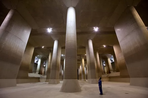
The real-life G-Cans. Photographer: Tomohiro Ohsumi/Bloomberg via Getty Images.
While tours of G-Cans are available during dry seasons, the Japanese Ministry of Land, Infrastructure, Transport and Tourism (MLIT) has made it possible to delve into this architectural marvel virtually through Minecraft. Their official YouTube channel features a video explaining the facility’s purpose and providing a glimpse of its blocky counterpart.
The free Minecraft map of G-Cans doesn’t stop at the underground structure—it includes an above-ground area with rivers, homes, and neighborhoods, offering players insight into how the facility safeguards communities in reality. Users can even step into the control room to simulate draining floodwater into the shafts, gaining firsthand knowledge of its operational mechanics.

The Minecraft G-Cans. Image credit: the Edogawa River Office.
Designed to educate the public about G-Cans and its role in preventing disasters, this Minecraft recreation also highlights the sheer scale of the facility. Stretching over 6 kilometers beneath Saitama Prefecture, part of the Greater Tokyo Area, G-Cans captures water from flood-prone rivers during Japan’s rainy season (June) and typhoon season (typically September). Gradually releasing the collected water into the Edogawa River and Tokyo Bay, it has been instrumental in mitigating flooding since its completion in 2006.
To access MLIT’s Minecraft map of G-Cans, visit the official website of the Edogawa River Office, which oversees the facility. Ensure you have at least Version 1.21.1 of Minecraft Bedrock Edition or Version 1.21.0 of Minecraft Education Edition installed.
![1xBet [Updated]](https://imgs.yx260.com/uploads/76/1719623227667f5e3be7616.jpg)